By Gustavo Zamora*, Buenos Aires (Argentina).
Published in gruasytransportes.
Weather conditions at a Port Terminal
Adverse weather conditions in which lifting operations may need to be reassessed include:
– high winds
– lightning
– poor visibility due to rain, snow and fog
– significant vessel movement.
Crane operators should base their decision to make a lift on the information provided by the crane manufacturer, advice provided by competent people like a rigger or engineer and their experience as a crane operator. Decisions may include ceasing crane operations if there is a serious risk arising from exposure to an immediate or imminent hazard, for example the possibility of the crane being struck by lightning. Any crane struck by lightning must be thoroughly examined before being returned to service. (Source 1)
Lessons from losses
Two separate crane accidents at a port facility during Hurricane Elena resulted in severe damage and extended downtime. At the storm warning stage, four portal cranes were bolted together and parked at the runway stop, with the last crane bolted to the stop. The equipment survived the initial high face of the storm. After the storm’s eye passed, the winds shifted direction and broke the anchor bolts, causing the cranes to roll down the runway. Three cranes fell into 100 feet of water. Further down the same runway, three portal cranes were parked individually without being tied together. Wheel wedges were driven in at the end of each crane, but the winds pushed each crane over the wedges. Two cranes crashed into each other and collapsed, and the third crane struck the two collapsed cranes. Experts later agreed that the cranes had been designed with adequate wind resistance, but the momentum of the crane once set in motion by high winds had not been adequately addressed.*
Insurers and risk managers of port facilities are becoming increasingly aware of the catastrophic loss potential posed by wind and other natural hazards. Damage to a crucial, multi-million dollar piece of equipment can spell financial disaster for a port, as an inability to move freight can translate rapidly into large losses of income. Ports cannot afford significant downtime.(Source 2)
Insurers and risk managers of port facilities are becoming increasingly aware of the catastrophic loss potential posed by wind and other natural hazards. Damage to a crucial, multi-million dollar piece of equipment can spell financial disaster for a port, as an inability to move freight can translate rapidly into large losses of income. Ports cannot afford significant downtime.(Source 2)
What the people with field experience say on the subject.
In gruasytransportes (GT) we contacted a Latin American executive with great experience in port operations (which we will call EG) to try to obtain deeper knowledge on this exciting subject.
GT: Only in Argentina, in the last 15 years, a minimum of 3 serious accidents have been recorded where at least 5 gantry cranes have suffered total loss or serious damages.
In at least two of those cases the strong winds ran from the West to the East, making the cranes on the pier run from West to East.
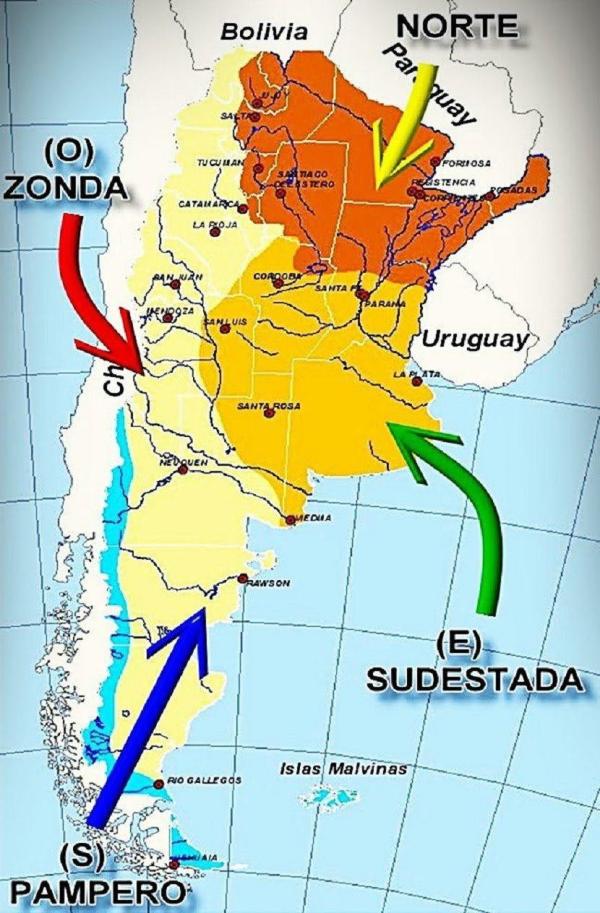
EG: You in Argentina and bordering countries have the Pampero Wind that goes ALWAYS from West to East. As I understand in several of the cases that you mentioned, the Pampero Wind was involved.
GT: Yes. That coincides with what is said lately, that there is a strip that runs from West to East in a large part of southern South America and that is known as the Corridor of the Tornadoes (or tornado corridor). You can read about it at <https://es.wikipedia.org/wiki/Pasillo_de_los_Tornados> and also at <https://www.elpais.com.uy/informacion/pasillo-tornados-zona-inestable-sudamerica.html>.
GT: I mention you as an example to follow that in other ports of the world such as in Port Nelson, New Zealand, the cranes stop their operations WITH A GUST of wind of 74 km per hour but if the wind comes from the East, then the cranes stop their operations WITH A GUST of wind of 55 km per hour. What can you tell me about that?
EG: That is an interesting way to be forewarned for two reasons. The first reason, you see that already with gusts of 74 km per hour they stop the operation when in other port terminals they doubt about if stopping the operation when the wind has a strong sustained speed and then large incidents occur due to it. And the second reason, is that I suppose that in Port Nelson they must have had great damages with wind coming from the East then because of that they take a higher safety margin of almost 20 km per hour of difference to stop their operation in the cases where the Wind comes from the East.
EG: Even so, I consider that the case of your wind called Pampero is very particular.
EG: I transcribe here part of an article written by Germán Portillo on the following site <https://www.meteorologiaenred.com/pampero-zonda-sudestada.html>
“The Pampero Wind.
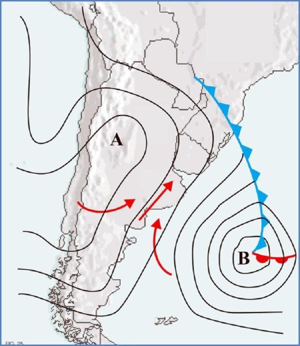
the pampero wind is formed by a low pressure center
The origin of the name goes back to the first arrival of the first Spaniards to the Río de la Plata who were sshocked by a strong wind from the southwest sector that brought fresh and dry air. The ancient colonizers observed weather changes in this region that were very different from those that were seen in Europe.
The Pampero has its origin due to a low pressures´center that is located on the plains of the center and northwest of Argentina. This low pressures’ center is strongest in Summer time and may attract the winds of the South Pacific anticyclone.
When a low pressures’ center is generated, for example when the temperatures make ascend a great amount of air to higher heights, the masses of air of around try to fill the place that has been with less amount of air. Therefore, all the winds found in the area of the South Pacific anticyclone move towards the low pressures’ center.
As mentioned before, these winds of the South Pacific anticyclone are cold and dry, since they act as a barrier and cause humidity to be lost. It usually blows on summer days and increases its temperature and humidity due to the arrival of the Trade winds – in Spanish, vientos Alisios-.
Thus, the Pampero wind advances quickly through the region named La Pampa, establishing a storm front in the area of contact between the two masses of air, since they have differences in terms of humidity and temperature.
The Pampero wind is the cold and dry mass, while the other is warm and humid, coming from the Trade winds. This contact between cold-dry and warm-humid masses cause electrical storms, abundant rains, even many times with hail and accompanied by a sudden drop in temperature. When the storm front disappears after a while, the weather becomes cool and dry again.
When the Pampero air loses humidity while crossing the Andes mountains , it is only cold and dry, and then it is called Dry Pampero. When provoking the precipitations by the storm front mentioned above, it is called Humid Pampero. If the southwest wind does not produce rains and produces dust storms it is called Dirty Pampero.
To know when Pampero blows, meteorologists look at the high pressure system that is located in the South of Brazil. This center of high pressures cause winds that blow over the Río de la Plata river and also over all the north and center of the country. As these winds blow, the temperature and humidity are constantly increasing and the atmospheric pressure is high.
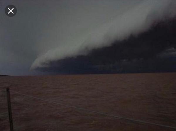
The wind can last between two and three days as the mass of cold and dry air is approaching and is occupying all the Patagonia region. Once this time passes, the pressure begins to fall gradually, while humidity and temperature maintain quite high values. Under these conditions a drop in pressure (up to 1.5 hPcal) is observed, and suddenly a dark line of clouds that are advancing towards the Rio de la Plata River is observed towards the south or towards the southwest.
These clouds mark the front of the cold that is moving towards the northeast at * 20-30 knots (37 km per hour to 56 km per hour, approximately) *”
1
2
Pictures of Diagrams 1 and 2
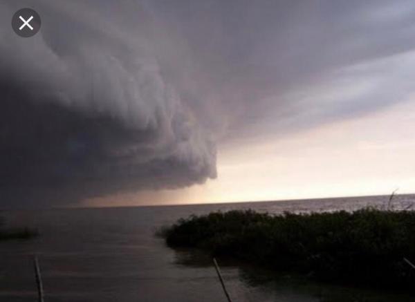
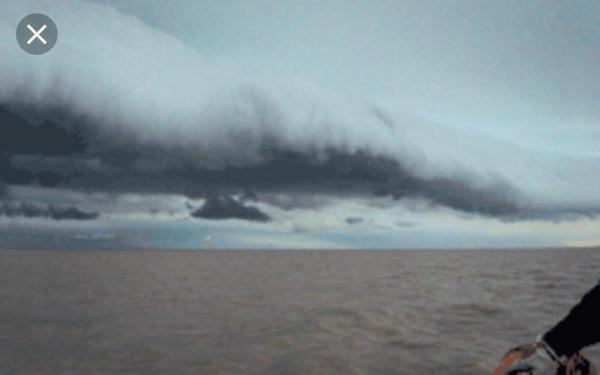
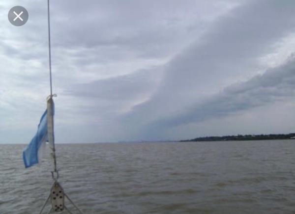
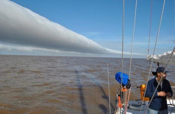
EG: The wind has a constant or almost constant speed of about 50 or 55 km per hour until the moment that the “loop” or “Cigar” passes over us producing one or several fast discharges – like bursts – with wind gusts that can reach 80 or 100 km / hour during a very short period of time (one or two hours as maximum).
EG: If your cranes are operating while the Pampero wind is being created there are two or three days of a quasi constant and high speed wind (50 to 60 km per hour) but that wind speed does not reach the level that is needed to stop the crane operations. That produces a habituation to the strong wind that, when the Pampero wind arrives with the consequent fast discharges –like bursts- it does not give you enough time to stop the operations, nor to block, nor to lash the cranes and in that moment the disaster is unavoidable.
EG: It’s not true that you can not foresee it; you can; if there is something foreseeable by the people that comes from the countryside or by the seafarers or by people who like nautical sports and even more by the professional people it is the estimated time of arrival of the Pampero wind to our position.
3
4
5
6
7
Pictures 3 a 7
GT: About four or five years ago, a wind of more than 115 km per hour crossed the whole Argentina from the West to the East causing huge damages to port terminals and airports. And about six or seven years before that mentioned episode, another high-speed wind that arrived from the West going to the East also caused very big damages to port terminals´ structures. Were those two cases also caused by that wind called Pampero?
EG: Yes, no doubt.
EG: From what you have told me and what I could find out those were events with high intensity winds or with high speed winds during a short time.
GT: And at night. When it is already dark, can we foresee and estimate the time of the arrival of that high intensity wind or high speed wind to our position?
EG: The answer is, when the Pampero wind passes over your position the temperature decreases, the air gets dry (the humidity of the air mass decreases) and the sky is cleared of clouds.
EG: Today you can anticipate the exact time of storm´s arrival, in order to be ready for the storm, an hour in advance of its arrival.
EG: Just by watching any of the 24-hour News TV channels you can and should be prepared.
GT: And then, what is the root cause of so many accidents due to those winds?
EG: That is a question that I prefer not to answer. Let’s concentrate better on explaining to your readers what happens and will happen with those winds so that they will be in the future better professionals than they are today, and thus avoid possible mistakes, recklessness or negligence in the fulfillment of their obligations.
GT: This is very interesting.
EG: Yes sir, it is.
EG: I thought you would tell me, if those are local winds or local meteorological phenomena, the locals should not know what to do and how to do with those events in their respective facilities and with their respective equipment?
GT: I do not ask that because, it has already been proven that the personnel of many port terminals sometimes even the local staff, all over the world and quite often, either they do not know what to do when the strong local wind arrives during the vessel operation because they often believe that nothing will happen to those cranes that are as big and heavy as the current gantry cranes and current mobile harbour cranes, or they prioritize the commercial side of the business and continue operating the ship at the expense of risking the safety of lives and equipment.
GT: That’s why I did not ask.
EG: The wind or the local winds in each particular location where there was an incident or accident regardless of the situation of the port terminals of your Argentina and also in South America have wreaked havoc in various locations around the world.
GT: Right. I got in touch with you because I see that the same happens all over the world and all the time and that even so, we still do not have taken all appropriate measures to avoid future incidents of this kind.
A few weeks ago a STS gantry crane fell into the water in Port Elizabeth, South Africa, in an event that was very similar to several ones that have already happened in places like Houston, Zárate and Buenos Aires.
GT: I thank you very much for sharing your knowledge with us.
EG: To the extent that we can, we must avoid this type of incidents in the future (source 3).
TYPES OF OPERATING EQUIPMENT AT A CONTAINER TERMINAL
In the port terminals there are ship to shore (STS) gantry cranes that, are mounted on rails,
they lift containers and loads from approximately 20 to 65 tons, they can have one trolley or double trolley, they have an approximate value of between 4 and 10 million US dollars.
These STS gantry cranes can move containers to and from the pier with a round trip cycle, every two minutes or less.
CRANE OPERATOR TRAINING
Operator training regulations fall under the Occupational Safety and Health Administration, Code of Federal Regulations (CFR) 29 Chapter XVII (7-1-89 Edition). Section 1918.97, “Qualification of machinery operators,” requires that an employer be satisfied that an equipment operator is qualified to operate a crane. However, 1918.97 does not contain standards for qualifications of machinery operators. As such, it appears that each port facility or stevedore company should provide its own training plans to assure minimum safety training.
For example, one major port facility has an ongoing training program for new employees. (The formalized training program for all crane operators was only established after a major loss involving two cranes, which collided into each other damaging both crane tower legs and causing one crane to collapse into the harbor.) The training program, which is divided by type of crane, provides four hours of classroom study and four hours of “hands-on” orientation for inexperienced operators. Practice session are conducted in groups of two until the operator understands the crane operations, at which time he or she is given a conditional card. Conditional card operators must be accompanied by an experienced operator at all times. Once conditional card operators prove their abilities and techniques, they are provided a certificate for that type of crane. The process is repeated for each type of crane.
EFFECT OF WIND FORCES ON CRANE OPERATIONS
Wind forces have the most significant impact on the safe operation of port and marine terminal equipment. The adverse effects of wind also determine the economic viability of a port to continue to operate. Strong wind conditions may force a port facility to temporarily shut down or curtail operations, and in such circumstances business also may be curtailed. As has been evident over the last several years, most port facilities have increased their operating range for wind speeds in order to counter downtime and economic impact to their operations.
The effectiveness of all procedures is contingent upon the preparedness of crane operators and the functioning of all safety devices. Without appropriate trial runs and safety monitoring prior to forecast winds, the effectiveness of such procedures are limited.
The following are some of the operating parameters* for port facilities and safety precautions.
1) Contract Weather Service
Most terminals subscribe to a contract weather service that furnishes, on a 24-hour basis, a specialized weather forecast specific for the operating area of the port. The weather forecast generally includes complete detail in layman’s terms of wind speed expressed in miles per hour, time of arrival, wind direction, high and low wind speeds (if gusts), predictable changes in wind direction and speed. The weather services also will notify when wind speeds are expected to diminish.
2) On-Site Wind Indicating Equipment
Most if not all shore cranes should be equipped with anemometers to indicate wind speed at the highest stationary point of the crane. Each operator cab should have a visual readout for the anemometer, a flashing caution light which flashes when the wind reaches a predetermined speed for initial alert, and an audible warning alarm. Operator cabs also should be equipped with two-way radios to permit contact with the central control station. In addition to anemometers installed on cranes, the central control station also should be equipped with continual readout in the event of failure of any one crane’s safety warning.
3) Written Procedures for Crane Operations in Wind Alert
Each operating terminal of a port facility should have written procedures governing the operation and shutdown of equipment during forecast and actual wind alert conditions, including emergency procedures during hurricane force winds. Because each port facility and its equipment may be unique, there should be distinct procedures for each.
4) Tie Down and Securing Procedures
Upon notification of shutdown procedures, the following actions are normally taken to secure equipment.
a) Luffing Portal Cranes: secure engine brakes, manual rail clamps and pins, secure rotating table.
b) Bridge cranes: secure engine brakes, automatic rail clamps, manual pins, and manual safety struts.
c) Where practicable, all equipment should be moved to “stowed” positions, with booms raised or lowered as applicable to the crane design, and latched in position.
d) Tie down turnbuckles should be applied when there is advance warnings of winds in excess of 76 mph (about 122 kph).*
LOSS PREVENTION SUMMARY
During the research phase of this paper, marine surveyors and loss prevention engineers expressed the following views and concerns, reflecting the state of loss prevention for port facility equipment owners.
1) Owners are paying more attention to wind protection and to safety lectures. Most container cranes are provided with automatic shutdown of lift gear when sustained winds exceed 40 mph. If that velocity is exceeded, rail locks are automatically engaged or the crane is moved to a pre-designated mooring and secured as recommended by the manufacturer.
2) Training programs for crane operators are being developed and enforced. However, there is little evidence of a basic uniform approach to assure consistency in the operator training and safety precautions, particularly across the spectrum of equipment in use today around the country.
3) Due to the frequency of loss from crane operator error or vessel operator error, crane operating procedures when ships are either stationary or arriving at berth need further examination. This becomes even more critical during a weather alert condition. (source 2)
==============================
Storm front video:
Published in youtube on Jan 09 2019 by gruasytransportes.
==============================
Download the new version of this post in English language as PDF:
Sources:
(1) Managing Risks in Stevedoring Code of Practice 2018 – WorkSafe QLD
(2) Port Facility Hazards-Factors Affecting Storm Safety
prepared through a cooperative effort by
Inland Marine Underwriters Association
RIMS Ports, Marine Facilities, Stevedores, and
Shipbuilders Industry Group
Inland Marine Underwriters Association
RIMS Ports, Marine Facilities, Stevedores, and
Shipbuilders Industry Group
Copyright ©1992 IMUA and the RIMS Ports, Marine Facilities, Stevedores, and Shipbuilders Industry
Compilation, interview and translation of gruasytransportes < gruasytransportes.wordpress.com>
(*) Gustavo Zamora is a specialist in lifting and cargo handling equipment. Lives and works in Buenos Aires (Argentina).
(1) y (2) Tags: is crane operator responsible for operating crane in heavy wind + who must stop crane operation at port terminal with heavy wind (gz36)
(3) Tags: Conversacion con ejecutivo sobre vientos en terminal portuaria (gz36), KB, KD, seguridad ante inclemencia meteorologicas para trabajo con gruas
(english version) Tags: Traduccion tormentas-y-fuertes-vientos-en-terminales-portuarias (gz37)
If you want to post this post on your own site, you can do it without problems,
as long as you do not modify it and cite as a source to https://gruasytransportes.wordpress.com
Remember to subscribe to our blog via RSS or Email.
Follow us on Twitter at @gruastransporte
Follow us on http://www.facebook.com/blogdegruasytransportes/
